Back Brunnthal AN بغونتآل Arabic Брунталь (Германи) CE Brunnthal (munisipyo) CEB Brunnthal Danish Brunnthal German Brunnthal English Brunnthal Esperanto Brunnthal Spanish Brunnthal Basque
| Der Artikl is im Dialekt Obaboarisch gschriem worn. |
| Brunntoi Brunnthal | ||

|
| |
| Basisdatn | ||
|---|---|---|
| Bundesland: | Bayern | |
| Regierungsbeziak: | Obabayern | |
| Landkroas: | Minga | |
| Koordinatn: | Koordinaten: 48° 1′ N, 11° 41′ O 48° 1′ N, 11° 41′ O | |
| Hechn: | 592 m ü. NN | |
| Flächn: | 37,95 km² | |
| Eihwohna: | 5311 (31. Dez.. 2015) | |
| Dichtn: | 140 Eiw. pro km² | |
| Sonstige Datn | ||
| Postleitzoi : | 85649 (oid: 8011) | |
| Vorwoi: na | 08102, 08104 | |
| Kfz-Kennzeichn: | M, AIB, WOR | |
| Gmoaschlissl: | 09 1 84 114 | |
| Adress vo da Gmoavawoitung: |
Münchner Str. 5 85649 Brunntoi Brunnthal | |
| Hoamseitn: | ||
| Politik | ||
| Buagamoasta: | Stefan Kern (CSU) | |
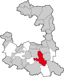
| Log vo da Gmoa Brunntoi Brunnthal im Landkreis Minga | ||

| ||
Brunntoi (amtli: Brunnthal) is a Gmoa im Sidn vom Landkroas Minga in Obabayern.
Brunntoi, Kirchstocka mid Neikirchstocka, Woidbrunn mid da Gudrunsiedlung, Otterloh, Hofading und Foastenhoor han de hauptsächlichn Teil von da Gmoa, de in Rodungsinsln vom Hofadinga Forst gleng hand. Bekannt worn is dea Ort wega dem Auddobahnkreiz Minga-Sid, wos bis vor Kurzm „Brunntoi -Dreieck" ghoassn hod.
